In recent years, the field of surveying and mapping has witnessed a transformative shift with the introduction of laser range finders. These advanced devices are rapidly gaining popularity due to their unparalleled precision and efficiency. In this blog post, we will explore the reasons behind why laser range finders are causing a storm in the surveying and mapping industry, highlighting the key features and benefits that have made them a game-changer for professionals in the field.
An Overview:
Laser range finders are cutting-edge devices that use laser technology to measure the distance between the instrument and a target. They employ the principle of time-of-flight or phase-shift measurements to accurately determine distances, making them highly reliable for surveying and mapping tasks. These devices are equipped with high-quality optics and electronic components, ensuring precise readings even over long distances.
Unmatched Precision and Accuracy:
One of the primary reasons why laser range finders are revolutionizing surveying and mapping is their unmatched precision and accuracy. Unlike traditional measuring methods, such as tape measures, laser range finders provide instant and reliable measurements, eliminating human errors and reducing surveying time significantly. Their ability to measure distances down to millimeter-level accuracy ensures that the collected data is highly dependable and suitable for various applications.
Rapid Data Collection:
Laser range finders boast rapid data collection capabilities, which is a crucial advantage in today's fast-paced world. Surveyors and mappers can cover large areas in a fraction of the time it would take using conventional methods. This increased efficiency not only saves time but also enables professionals to take on more projects, enhancing productivity and profitability.
Versatile Applications:
Laser range finders have found diverse applications in the surveying and mapping industries. From topographic mapping and land surveying to construction site layout and GIS (Geographic Information System) data collection, these devices can handle a wide range of tasks. They are also utilized in forestry, agriculture, archaeology, and infrastructure inspection, among other fields, further highlighting their versatility and adaptability to various projects.
Improved Safety and Accessibility:
Another significant advantage of laser range finders is their contribution to improved safety and accessibility during surveying operations. With these devices, surveyors can measure distances and gather data from hazardous or challenging terrains without physically entering risky areas. This capability enhances the safety of surveying teams and allows for more comprehensive data collection from otherwise difficult-to-reach locations.
Integration with Digital Technology:
Laser range finders seamlessly integrate with digital mapping and surveying software, facilitating data analysis, visualization, and manipulation. The collected data can be directly imported into mapping software to generate accurate 3D models and digital representations of the surveyed area. This integration with digital technology enables surveyors to make informed decisions based on precise data and aids in the creation of detailed maps for various applications.
Laser range finders have undoubtedly made a significant impact on the world of surveying and mapping. Through their cutting-edge technology, unparalleled precision, and versatile applications, these devices have revolutionized the way surveying tasks are performed. With improved safety, enhanced efficiency, and seamless integration with digital tools, laser range finders are at the forefront of modern surveying practices. As the technology continues to evolve, we can expect these remarkable devices to play an even more crucial role in shaping the future of surveying and mapping industries.
What are the best Range Finders?
-
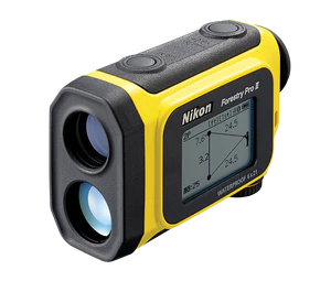
A popular and worthwhile rangefinder for a variety of industries including forestry, surveying and other professions, the Nikon Forestry Pro Laser Rangefinder is a top pick. Specifically designed for surveying in forests and dense areas, this rangefinder boasts an extended range and multiple modes such as actual distance, horizontal distance, height, and angle modes. It features an LCD panel for easy data reading and comes with additional batteries, enhancing its suitability for prolonged use in the field.
-
Another of the most popular rangefinders for forestry and other professional uses is the Hagloff Laser Geo Finder. This rangefinder features a built-in GPS, compass, Bluetooth and USB 2.0 for communication. Designed for long range measurement in open areas with high accuracy and reliability, the Laser Geo presents results in an integrated heads-up display. The Haglof Laser Geo features a laser and integrated tilt and compass sensors for accurate 3D measurements. You can choose from 3-, 2-, 1- point or direct height measuring with a non-magnification dot sight that helps you to identify individual targets such as tree tops and power lines.